AccuWeather forecasters say a massive shift in the weather pattern is on the way for North America next week. Summerlike heat is expected to build over the western United States as a surge of Arctic air is projected to plunge into the eastern half of the nation. Both high and low temperature records could be broken amid the extreme weather setup.

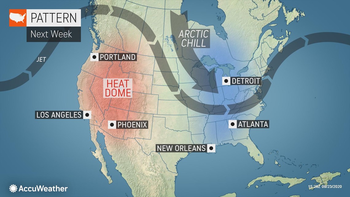
Cold wave for the eastern half of the US
An outbreak of the coldest air since last spring will sweep across much of the eastern half of the U.S. next week.
"The change in the pattern will come in two waves," said AccuWeather Long-Range Meteorologist Tyler Roys. "After a warmup during the second half of this week, an area of low pressure sweeping across southern Canada will usher in an initial cooldown again from the northern Plains through Great Lakes and into the Northeast during the second half of this weekend into early next week."
The first push of cooler air will serve to bring temperatures back to near normal, or a little below normal for late September, and it will be limited to northern areas. Across the Southeast, temperatures will remain a few degrees above normal.
Normal highs are generally in the middle to upper 60s in the northern Plains, Great Lakes and Northeast during late September. Farther south, temperatures typically climb into the lower to mid-70s in the mid-Atlantic through the Ohio Valley and into the mid-Mississippi Valley, and upper 70s to low 80s across much of the Southeast and lower Mississippi Valley this time of year.

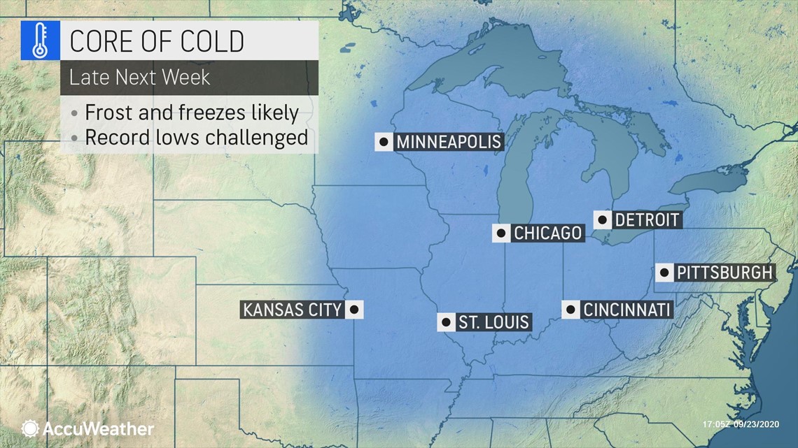
"The real cold shot will be ushered in later next week as a stronger storm system pushes from the northern Plains through the Great Lakes," Roys explained. "High pressure building down from northern Canada and a deep dip southward in the jet stream will bring a continuous flow of cold air straight from the Arctic, directed toward the eastern U.S. It may take until Friday or Saturday of next week for the cold to peak."
The core of the cold is expected to be aimed from the Midwest and Mississippi Valley to the Appalachians. From Wisconsin to the central Gulf Coast and from eastern Kansas to West Virginia, temperatures are forecast to be 10-20 degrees Fahrenheit below normal during the height of the cold shot.
Interior portions of Louisiana, Mississippi, Alabama and Georgia, areas weary from the record-setting tropical season, could have afternoon temperatures topping out in the 60s and overnight lows dropping into the 40s. Some communities still cleaning up and without power from Laura, Sally and now enduring flooding rainfall from Beta will face chilly weather.
Frosts and freezes could threaten sensitive agriculture from as far south as parts of the Ozarks in northern Arkansas to the Blue Ridge Mountains straddling Tennessee, North Carolina and far northern Georgia.
Even in Atlanta, low temperatures could drop to the mid-40s, with lower 40s in some outlying areas. The normal low in Atlanta at the end of September and beginning of October is around 60 degrees.
"While the Great Lakes and interior Northeast were hit with a cold snap that led to the end of the growing season last week, this next shot of cold will target areas farther west, and will likely end the growing season across much of the Midwest and Ohio Valley," Roys said.
Afternoon temperatures are expected to be stuck in the 40s and even some in the 30s across the Upper Midwest and northern Great Lakes. Lake-effect rain showers and a raw, gusty wind will also add to dreariness and the feeling of chill. During the overnight hours during the height of the cold, some parts of the Great Lakes may see their first snowflakes of the season.
Overnight lows will plunge with widespread temperatures projected to be in the 30s and 40s and even some 20-degree readings for locations from the eastern Plains to much of the interior Northeast and mid-Atlantic.
Along the Eastern Seaboard, the cooldown will be felt, but the core of cold will grip areas farther west. "Most locations east of the Appalachians and along the Interstate 95 corridor will be around 5-10 degrees below normal," Roys said.
Normal high temperatures along the I-95 corridor for the start of October range from the mid-60s around Bangor, Maine, to the middle to upper 70s around Raleigh, North Carolina.
Heat wave to grip western US
While the eastern U.S. shivers, people in the West will be cranking up air conditioners again as an expansive heat dome envelops the region.
"As is often the case when the jet stream dives south in the eastern U.S. bringing cold air, the jet stream will bulge northward in the western U.S., allowing a ridge of high pressure and heat to build," Roys explained.
Even though some in the Northwest are getting a respite from dangerous wildfire conditions this week, for many in the West the heat wave that will build next week will only add to what's already been an arduous wildfire season fraught with widespread drought.
Las Vegas' record dry streak continues, and the city is also challenging the record for most 100-degree days in a calendar year. As heat intensifies next week, both of these tallies will continue to grow.

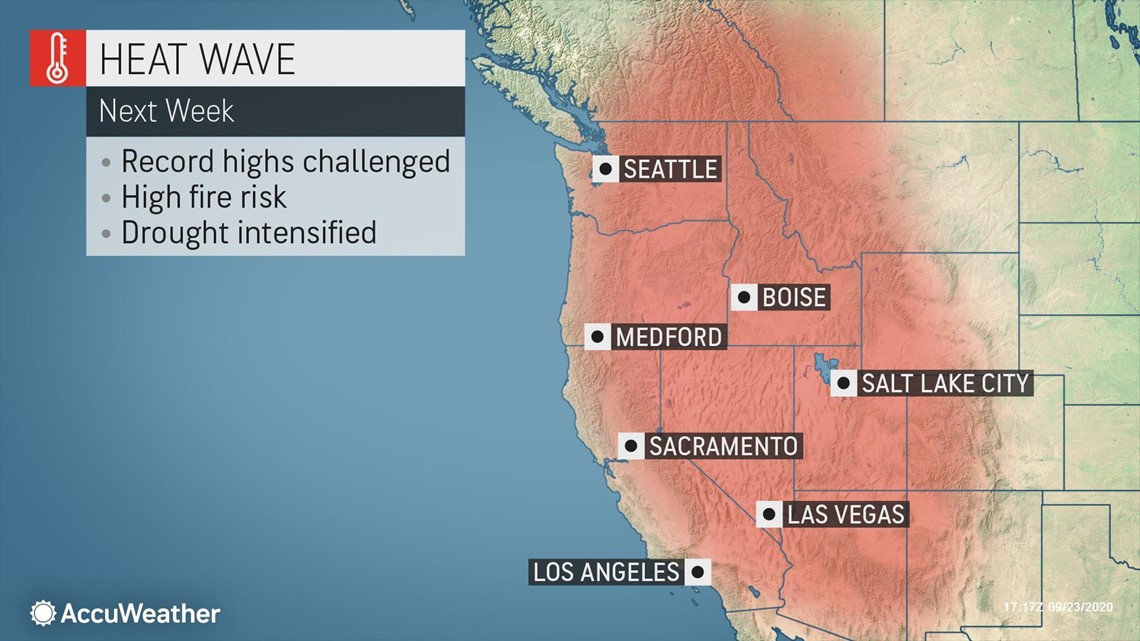
As temperatures plummet 10-20 degrees below normal in the East, they will soar 10-20 degrees above normal across much of the West.
Triple-digit high temperatures will become widespread again from Central and Southern California and across the Desert Southwest. Even San Francisco, usually kept cooler by marine air and an onshore flow, could climb into the 90s as winds begin to blow offshore instead.
Portland and Seattle will experience well above-normal warmth and sunshine after picking up heavy rain and feeling a big cooldown this week.
The switch to an offshore flow could also become particularly troublesome for firefighters still battling many large fires across the region.
"When the winds blow offshore, they transport the hot and very dry air from interior areas right to the coast. In some places, where they blow from higher to lower elevation, the air heats up even more as it descends," explained AccuWeather Meteorologist Brett Rossio.
In Northern California and western Oregon, where some of the largest wildfires have burned, winds will turn gusty early next week as well.
"As the strong high pressure that will eventually help deliver the coldest air to the East first moves across the Northwest, it will cause a greater difference in pressure between the Northwest and Southwest," Rossio said.
The setup will create large differences in pressure and in turn drive stronger winds. "Early next week this will be focused over Northern California and Oregon," Rossio said.
Rain this week may alleviate what may otherwise have been an extreme fire threat in Oregon, but Northern California is unlikely to be as lucky. Very little to no rainfall is expected to reach the parched region ahead of increasing winds.
In the Los Angeles area, gusty winds could also hinder efforts to contain the Bobcat Fire, now one of the largest fires in Los Angeles County history. The fire is burning very close to Pasadena, California. As high heat, very low humidity and gusty northeast winds develop early next week, they could bring the potential to drive the fire right into the highly populated L.A. suburb.
During the first full week in October, this extreme kink in the jet stream is expected to ease, bringing conditions back closer to normal across the nation. However, that could also mean a return in activity in the record-setting 2020 hurricane season.

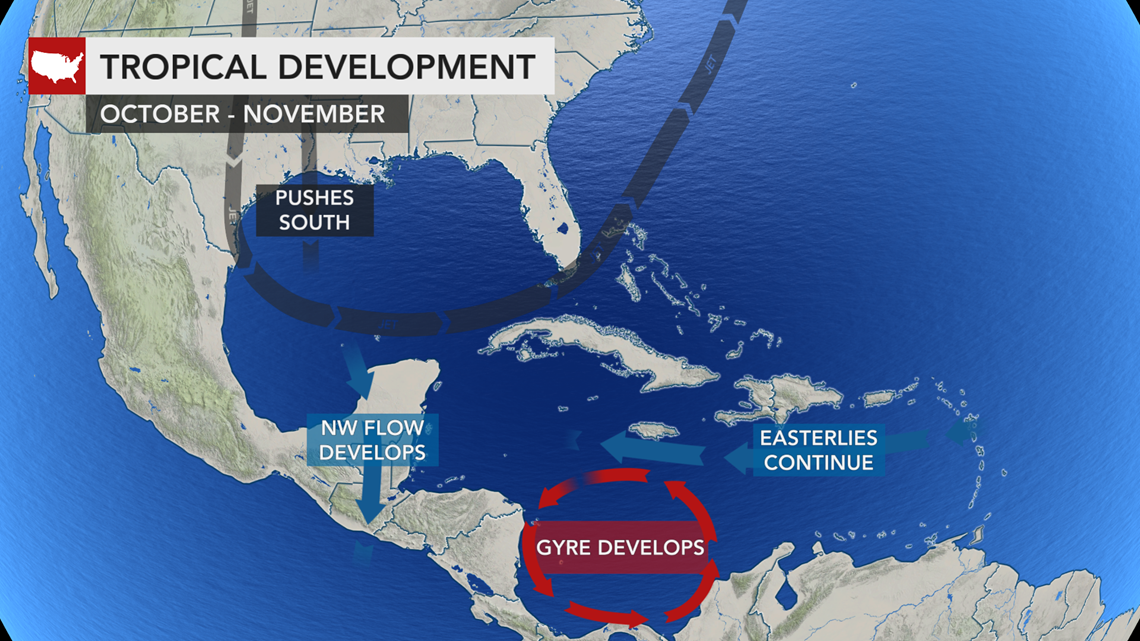
"Computer forecasts continue to show the development of a large counterclockwise wind pattern over Central America, commonly referred to as a gyre, later next week. This could lead to the development of an organized tropical system in the southern Caribbean during early October," said AccuWeather's lead hurricane expert Dan Kottlowski.

